After a full week in Kathmandu, we’re finally making our way to the Everest Base Camp! The last days of April were full of positive signs. Little by little, life in the city started to get back to normal; streets got busy with people, cars and bikes, and shops and restaurants began to re-open. We celebrated each one of those changes as an achievement: “look, that store wasn’t open yesterday”, “wow, a taxi driver just solicited me”… Professional teams are already working on clearing debris and reconstructing Durbar Square and other historic sites. Unfortunately, most Nepalis won’t get that much support. But at least there is a path forward, and tourism will play a major role in it. So please don’t stop coming to Nepal, this country and its people are wonderful.
We booked flights to Lukla, rented some mountain gear in Thamel (down jackets, sleeping bags, hiking poles and goretex pants), and were ready to go. After a mere 24 hours delay (quite common for this route), we finally took off on the morning of May 1st.The highlights of the 25 min flight were the views of the Himalayas (try to seat on the left side of the plane) and the crazy landing on the short airstrip trapped among giant mountains. We walked into a teahouse to get some hot cocoa and re-assess the situation post-earthquake, talking to people that were coming down. The were more good than bad news, and we were more decided and excited than ever; it was a go. We interviewed a few porters and decided to go with a 30-something local named Lama. His English was very limited, but he had ties in the Lukla community, a cellphone, and knew what to do in case of emergency. For $15 per day, he would carry our big backpack, and cover his own accommodation and food.
At 9 am, we walked out of Lukla and started hallucinating with the scenery: snow-capped mountains, green valleys with turquoise rivers, hanging bridges, yaks, sherpa porters, Buddhist monasteries, stupas, praying wheels… and red-cheeked children. In 2 hours and 15 min we reached Phakding. A quick lunch of momos (dumplings) and rice gave us the necessary energy to continue. 3 hours later we arrived at the small village of Jorsale, just 20 min past Monjo and the official entrance of the Sagarmatha National Park. We got a room at the Nirvana lodge, of solid construction and cozy, for $4 a double with shared bathroom. We hang out by the stove until 6 pm, eat some traditional dal bhat, and went to sleep.
In the middle of the night, the owner woke us up, and told us that we had to evacuate to Monjo. We got ready as quickly as possible and hiked back 20 min, in the pitch dark night, in the middle of a brutal storm. Once we reached a hostel on higher grounds, we learnt that this had nothing to do with the earthquake, that a large piece of glacier had broken upstream and the river could go out of control, we we weren’t safe… ARE YOU KIDDING ME?!?!
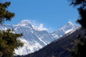
Yesterday we hiked back to Jorsale early in the morning to get our stuff (everything was ok), and get going. Because we had advanced past Phakding on the first leg, were most trekkers stop, we had a much easier second leg left to Namche Bazaar. It took us less than 3 hours, though it was really steep uphill. The views were even more stunning than the previous day: 6,000m peaks, a glacier river, the tallest/scariest suspension bridge I’ve seen. We needed to gain 600m of elevation, and every 200m there was a “rest area”. From the second one, we caught our first view of Everest and its neighbor Lhotse.
The trail to Namche was less tortuous than we had heard, definitely would recommend pushing past Phakding on your first day. Namche Bazaar, at 3,440m and perched in a natural amphitheater, is the most developed village in the area. It was also one of the most affected by the quake, and a few teahouses remain closed. We found accommodation in the Kamal Hostel for $2 per night, with private bathroom and hot shower (maybe). In Namche there are numerous shops and restaurants, even bakeries. Food, however, is very expensive, about $5 for a dish. As you can see, there is also Internet 🙂
We had to stay here for 2 nights to acclimatize properly. On a “rest day”, it’s important to stay active and gain a bit of altitude before coming down. So today we climbed up to the Sagarmatha Visitor Center (currently closed, hosting military personnel in the area for relief missions), and further up to what’s considered the highest hotel in the world. We were rewarded with some epic views of Everest and the surrounding peaks; Ama Dablam is still my favorite. We’re sore and cold, but feeling good overall. Tomorrow we will continue up to the remote villages of Tengboche, Dingboche, Lobuche and Gorak Shep. If all goes well, and including 2 more acclimatization days, we should be back in about 10 days, and will try to post asap.


Pingback: Namche-Tengboche-Dingboche-Lobuche | Bona Travels
Pingback: Country summary – Nepal | Bona Travels
I saw your feature image, this is in Sherpa Museum in Namche right? Whose statue is this? When I was there they were planning to inaugurate, so I didn’t get proper information. Meantime I’m trying to operate a informational website about Everest Trek, do check it out. I had listed a list of frequently asked questions about trek and a embedded a nice trek map. Your suggestions are valuable. Check FAQ and Map via link below:
http://www.everestbasecamptrek.org/everest-trek-faq
http://www.everestbasecamptrek.org/everest-base-camp-trek-map-online/
LikeLike
Pingback: My experience climbing Everest (1/3): Base Camp – Bona Travels
Thanks to sharing a stunning photograph of en route of the Everest base camp trek.
LikeLike